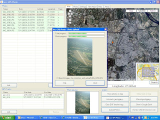
 Was recently out for a trip to Dehradun via Delhi, took some intresting photos and geo tagged them using Satguide GPS logger device. http://www.satguide.in/satguide-photo-logger.pdf,
for the uninitiated, geo tagging is a process of adding location information (latitude and longitude) on to the digital photograph.
Photograph taken from a digital camera confirms to EXIF (Exchangeable image file format), this specification uses specific Meta tags which store information such as date, time, camera make, settings etc
· What I have done here is that I have switched ON the data logger device which started logging the GPS feed, I started clicking my pictures through my Canon D400 DSLR , note that there is no communication between the GPS logger and the Camera
· Installed, locr Desktop geo tagging application (by the way you can choose from a variety of geo tagging freeware tools)
· Imported the logged data to the desktop tool.
· Imported the photographs and supplied to the desktop tool, the tool is very intuitive, as you can see form the screenshot above.
Clicking the automatic geo tagging button will automatically geotag your images. The technology here is simple, the GPS logger device output file has a time stamp, images you take from the digital camera also has the time stamp ( we need to set this time to our real world real-time time ;), i.e just the actual time). The software matches the timestamp of the image to the timestamp of the log and automatically geotags. As exact millisecond time synchronization is not possible, it’s not needed either, you only need to keep the time matching tolerance level to say 2 minutes in the desktop too, you have a geo tagged image in a jiffy.
The positional information now will be written into the image itself and will be position enabled, you can upload these images on to any of the photo sharing community websites, and the photograph automatically goes and sits at the exact place on the map you guys have taken…
Geotagging and dissemination of this accurate location enabled image information though is fun, has important functional usage in many domains. Points of Interest’s Survey are what come to my mind immediately.
3 comments:
Quite informative…Thanks for sharing the post..
regards
GIS spatial analysis
This was really very informative. One question though. If matching tolerance is set to 2 minutes, what happens if I take multiple photos in 1 minute and when you are flying?
Ummh, I have not tried this ;) Software will probably show the nearest match I guess. Anyways, geotagging / synchronization would not be accurate in any case because the Aircrafts travel at speeds ranging from 500 to 800 Km per hour at cruising levels
Post a Comment